Dave Moulton

Dave's Bike Blog

Award Winning Site

More pictures of my past work can be viewed in the Photo Gallery on the Owner's Registry. A link is in the navigation bar at the top

Bicycle Accident Lawyer


Powered by Squarespace
Search Dave's Bike Blog


 Watch Dave's hilarious Ass Song Video.

Or click here to go direct to YouTube.


A small donation or a purchase from the online store, (See above.) will help towards the upkeep of my blog and registry. No donation is too small.

Thank you.

Join the Registry

If you own a frame or bike built by Dave Moulton, email details to list it on the registry website at www.davemoultonregistry.com

Email (Contact Dave.)

 If you ask me a question in the comments section of old outdated article, you may not get an answer. Unless the article is current I may not even see it. Email me instead. Thanks Dave

Entries in Lowcountry Bike Rides (20)

Thursday
May082014

Sawmill Bike Path, closure at Bacons Bridge Road.

This post is for the benefit of my local area cyclists. The popular Sawmill Branch Walk and Bike Path in Summerville, South Carolina, is closed at the bridge that takes the path under Bacons Bridge Road (165.) due to road widening and bridge work. I am sure it will be closed for the rest of 2014 and may run into next year.

There is a fairly easy diversion but it is not official and consequently is not marked. If traveling east, turn left on the paved path just past the Pump house, about a quarter mile before Bacons Bridge. The path joins residential streets, turn right, and right again on Holly Street.

Holly Street emerges on Bacons Bridge just above an entrance to the bike path on the opposite side. Bacons Bridge is a busy main road, but experienced cyclists should not have a problem crossing. I am sure this diversion will not be officially marked because of the problem of crossing Bacons Bridge. I would not recommend it for the inexperienced or feint hearted.

The good thing is, in either direction you make a right onto Bacons Bridge Road, so you wait for a gap in traffic, then turn right. Oncoming traffic on the opposite side is clearly visable. Take the lane, and wait for a gap in the opposing traffic, and complete the next left turn. Make sure you use a hand signal so everyone knows what you are doing. The road works on the bridge does tend to work in our favor, as it slows traffic.

If traveling west towards Down Town Summerville, take the right fork where the trail splits, and emerge on Bacons Bridge. Turn right, and left in about 50 yards into Holly Street. In about a quarter of a mile turn left (It’s a dual entrance, with a sign that says "Arbor Oaks.") after turning go straight, and after a right hand curve, look for the path entrance on the left, to rejoin the Sawmill Trail.

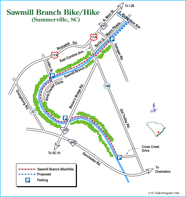
The Sawmill Branch Trail Is used as a safe route to get from one end of Summerville to the other. Many cyclists on weekend rides on local rural roads use the Sawmill Trail as a means to get there. I intend to keep using the trail during these road works, I hope others will find this diversion useful. Please, stay safe and use extra care while using this alternate route.

Update 8/26/16: The bridge has re-opened. See picture below.


 To Share click "Share Article" below 

Monday
Aug202012

100 miles, solo

Ever since I got my new Fuso at the end of June I have been enthused to ride more and ride longer distances. The last two weekends I have ridden 75 miles and I felt I was ready to try 100 miles.

It was an ambition that I had for some time now; I put the word out with the local group I ride with, that I might try riding from Summerville to Folly Beach, but no one showed interest in joining me. So last Saturday I decided to set out on my own.

The plan was if I didn’t feel up to completing the distance I would turn back early. I did not choose the direct route for two reasons. Hwy. 61 (Ashley River Road.) the direct route from Summerville to West Ashley, is not a safe road to ride a bike.

A narrow two lane highway with a lot of dangerous curves through old growth forest. A pretty road to drive, but make shift memorials of crosses and plastic flowers nailed to large trees all along the route, mark where drivers ended their days. The second reason, the longer route made the distance 50 miles one way; 100 miles out and home.

For my local readers the route I took was: 61 Hwy. for about 4 miles actually going away from the coast. Left on Summers Drive, a brand new road built in the last year or so; wide with bike lanes on both sides, and light traffic.

Left again on Clubhouse Drive, to Hwy. 165 briefly then Countyline Road another quiet country road that goes all the way down to Savannah Hwy. (17.) which is not a pleasant road to ride on, being the main route from Charleston to Savannah.

Traffic is extremely heavy, but there is a shoulder with a rumble strip to help keep cars off, and I was only on it for a couple of miles, before turning off on Main Road and over the Stono River Bridge (Below.) to John’s Island.

Left on River Road, left again on Maybank Hwy. Over the Stono River again to James Island. Right on Riverland Drive which bypasses the dangerous part of Folly Road and links with it where the bike lanes start.

Over two more bridges and finally on to Folly Beach; also known as “The Edge of America.”

Folly Beach is a narrow strip of sand that is a barrier island.

It has a nice beach, a pier (Picture below.) and a light house.

It turned out that I picked a perfect day for the ride. I had left at 6:15 am. when it was barely light. It was cloudy, overcast, even a little foggy in places; temperatures were in the 70s F. (21C.) The sun didn’t show until around 10 pm. just as I reached Folly Beach.

I took a 40 minute break and had breakfast at a restaurant on Folly Beach Pier. Omelet, hash browns and toast; two large cups of coffee, and several glasses of water. I also filled my water bottles for the return trip.

I felt good on the return trip; I started to sag a little at about mile 85. I stopped, took a 10 minute break, and drank a lot of water. That did the trick, I felt fine after and actually finished the ride at a pretty good pace.

Temperatures were around 85F. (29C.) by the time I got home; not too hot for South Carolina at this time of year. I arrived home soon after 2:00 pm. 7 hours actual riding time.

A nice sense of achievement to have completed 100 mile bike ride; my first in the US actually. The last time I rode a 100 in one day was back in England in the mid and late 1970s; and that was with a group, not alone.


Monday
Jan092012

One step forward, one step back


The old city of Charleston, South Carolina is built on a peninsula with the Cooper River to the north east, joining the Ashley River to the south west.

One of the ways in and out of the city, over the Ashley River is to use Savannah Highway 17. (Picture above.) The road splits and twin bridges carry the traffic; one bridge has four lanes going into the city, the other bridge has three lanes out.

There is no shoulder or bike lane and riding in the traffic lane a cyclist is squeezed up against a 9 inch high curb of a sidewalk that is barely 24 inches wide. (See picture left.)

I would not recommend riding the sidewalk either; it is not much wider than your handlebars and is not for the timid. One false move would send you off the edge of the 9 inch curb and tumbling in front of speeding cars.

To make matters worse the center section on both bridges is a draw bridge to let boats pass under. This center section is made of steel grating that is treacherous for skinny tired road bikes, especially when wet. Some commuters choose to dismount and walk their bike across. (Below.)

Last month the South Carolina Department of Transport (SCDOT.) agreed that the City of Charleston could designate one of the four inbound lanes as a separate two way bike and pedestrian lane.

The lane is to be protected from automobile traffic by a cement barrier; also special on/off ramps for cyclists and pedestrians will need to be constructed.

This was welcome news for people who commute in and out of the city by bike, and the recreational cyclists who cross the Ashley River to reach some of the area’s best riding on James and Johns Island. However, the City has yet to find the money to carry out this project; it will be two years or more before we actually see this happen.

The only other way in and out of Charleston over the Ashley River is to use the James Island Connector Road. (Below.) Not ideal for cyclists I would agree, as it is designed with freeway style on/off ramps. But it does have an eight foot wide shoulder, and is a far safer route than taking Hwy. 17 as I have just described.

So imagine the dismay and disappointment for local cyclists and advocacy groups when the SCDOT told the city last week that it was illegal for cyclists to use the James Island Connector. In fact they are saying that it has been illegal since the road was built but the law has never been enforced.

This is the road where Mitchell Hollon, a much loved local anesthesiologist and cyclist, was killed last summer when he was struck by an AT&T utility van whose driver had wandered onto the shoulder. One can’t help but wonder if Mitchell’s death has prompted this cycling ban, although Charleston’s Mayor Riley says it is not the reason.

It is the old “Blame the Victim” scenario. A cyclist doing absolutely nothing wrong, is killed and instead of taking steps to make things safer for cyclists they think it solves the problem if they ban them altogether.

Why not extend this "Blame the victim" approach to other areas? There are also the occasional muggings and murders of people walking the streets of downtown Charleston at night.

Why doesn’t Mayor Riley take the same approach and stop this criminal activity by banning tourists and enforcing a late night curfew downtown. Let's cut down on attacks on females by banning them from jogging trails. (I am being facetious of course.)


I am not a legal expert and I would welcome input from those who are; but I question the legality of this ban. It has been my understanding the only roads barred to cyclists are freeways. The James Island Connector is not a freeway, although it will be eventually when it is extended to join up with the I-526.


There is no reason why in the interim cyclists can’t be allowed to continue use of the JI Connector road at least until the Hwy. 17 bridge improvements have been made.  If that is not possible, how about some“Sharrows” and signs saying cyclists may take the whole lane on the Savannah Highway bridge.

Maybe a 30mph speed limit on the bridge; of course the local motoring public would be up in arms against this, but really is there any point in rushing the half mile over the bridge to wait at a traffic light on either side.

Footnote: 1/11/12

Charleston is fortunate in that it has a local newspaper, the Post & Courier, that is pro cycling; all too rare in the US. Here is an updated article on the Ashley River bike crossing issue.

Update: 1/24/12

The ban is official, signs are posted on JI Connector.


Monday
Sep192011

Find another route

Derrick Harrison rides his bike to Downtown Charleston each day to his job as a line cook in a restaurant on Queen Street.

His route takes him south on Anson Street then west on Queen Street. Therein lies a problem; Anson is one way going north.

Charleston police have started ticketing cyclists for riding the wrong way, and Derrick has picked up three tickets in the last month, costing $100 a pop.

So has this deterred our wayward bike commuter? No way… According to this story in our local Post & Courier Derrick continues to ride the wrong way on Anson; he would rather risk another ticket than risk his life on parallel Meeting or East Bay Streets.

The question I would ask Derrick is, “Do jobs as line cooks pay so well that you can afford to do that? And while I agree Meeting and East Bay are not good streets to ride a bike, do you think riding the wrong way on a one-way street is safer?”

Cars entering such a street from side roads look only in the direction traffic is coming; they are not expecting cyclists from the opposite side.

Pedestrians too are at risk; in this case I am with the police in issuing tickets.

Look at the map above, Old Town Charleston is a peninsula; its streets are laid out in a rough grid pattern. The streets marked in yellow are the main though routes, I even try to avoid these in my car, and would definitely give them a miss on my bike.

However, there are many other streets that go north and south, and east and west; some are quiet residential streets with little traffic.

For cri’sakes Derrick, find another way to and from work; seeking out alternative routes is one of the fun things about bicycle commuting.

Swing over to the west, find a quiet street to take you south; Queen Street is one way going west so just continue south until you reach Tradd Street (South of Broad.) for example. Take Tradd east until you are past your place of employment, then head north to Queen.

So this might add a mile to your trip, just leave home five minutes earlier. Of course if you would rather keep giving the City of Charleston your hard earned money, I am sure they will be happy to keep on taking it.


Thursday
Apr142011

Actually going somewhere

I love riding long distances; I always have. As a teen I would ride up to 50 miles in an evening after school; and on the weekends up to 100 miles.

I often did these rides on my own as friends my age were not keen to cover these distances. Later at age sixteen after I joined a club, I started riding with adults aged twenty years and older.

We would often go on weekend rides in excess of 100 miles. At age 17 I rode in the National Championship 12 Hour Time Trial, and covered 220 miles in the 12 hours.

In order to enjoy riding these distances it is necessary to be at a certain level of fitness, otherwise the rides become a great deal of suffering and less pleasure. I am just starting to reach that level once again; in the last six weeks I have been riding 200 miles per week.

I have been riding with a local club group on Saturdays; there are three groups at different levels. The elite group is a little too fast for me riding at 20 to 25 mph; but the intermediate group mostly made up of guys around fifty years of age, ride about 65 miles averaging around 17 or 18 mph.

During the week I mostly ride on a local bike path; I am glad that it is available to me, but at barely 7miles long, 14 miles out and back, by the time I have done this three times, (About 42 miles.) I am bored out of my skull, and that is about as far as I can manage.

Plus there is the added hassle of dealing with runners and walkers wearing I-pods, and assorted other slow bike riders, dog walkers, etc.

Yesterday was a beautiful day, sunny, 70F (21C.) with a 10mph breeze; I decided to take to the open road and actually go somewhere. I rode from Summerville to John’s Island, a round trip of 75 miles.

The map above shows the route I took marked in red dots. I left Summerville on Route 165, a favorite way out of town with local cyclists, traffic not too heavy. Turned off on County Line Road which is a rural road where I saw on average about one car per mile traveled.

Hwy. 17 is the main road from Charleston to Savannah and has heavy traffic; it is a divided highway with two lanes either side. However, it has a decent shoulder, and I was only on it for two miles before turning off on Main Road that took me over the Stono River to John's Island.

The Stono River Bridge is a tall bridge built to accommodate boats with tall masts that pass under. This makes it a steep little climb, and a good gauge of one’s level if fitness. Once over the bridge, I made a right onto Chisholm Road.

Another favorite with local riders, Chisholm is a quiet road that services farms and private homes; most of the road is shaded by old growth trees on either side. My turn around point was at John’s Island High School where Chisholm meets back up with Main Road again.   

The ride took me just five hours, an average of 15mph; not bad for an old guy riding solo. I had a headwind on the homeward leg, and I took three separate 10 minute breaks, to eat and rest up a little.

I’m not sure why I like riding distances; I guess I just enjoy riding my bike, and a long ride gives me more time doing just that. There is a great sense of achievement, and satisfaction on completion of the ride, and the thought that I actually went somewhere, as opposed to riding up and down a bike path going nowhere.

I turned 75 on my last birthday earlier this year, and I realize I will not be able to keep up these long rides indefinitely. I am sure I will be riding for many years to come, but the question I ask myself is, can I maintain the fitness level required to ride the distances?

Just so you know I do practice what I preach, above is my bike. Note the handlebars are 2 ½ inches (63mm.) below my saddle. My reach is 1.5cm. shorter than when I used to race. I mostly ride on the hoods; I suffer no back or neck pain on these longer rides.